
Bryanbryoil
Pray For Ukraine
- Sep 13, 2004
- 86,301
- 35,010
Except Tomatoes are native to South and Central America")
Pffft, next thing you're going to tell us that corn is from North America...
Except Tomatoes are native to South and Central America
Heirloom tomatoes, ugly but beautiful inside.Yep. I got a variety of tomatoes. dogs breakfast in there. 3 types of smaller tomatoes, 3 type of larger including san marzano and Pomodori tomatoes. I like using them in sauces and dishes. Others just for salads, eating raw.
Even my Cucumbers, so much more taste than store bought.
Some updates, my Hungarian wax wing tomatoes are going crazy good this year.
Peas are doing best ever, and I have two locations, one in more of a shade location and I suspected they would prfer that. Also that I staked them and support them with long bungee cords which I just elevate as the plants grow. The pea plants really like this and as a result are pumping peas out for months. I've nver seen this before. Usually our pea's are limited time producing. These plants are thriving, thick and tall.
Grapes like crazy, bunches. Already some ripe. (Valiant species, red -blue grape)
Basically everything this year was among best ever production. We got one freezer loaded already and working on second one. We're self sufficient with most veggies. Still finishing up last years swiss chard, carrots, beans, beets etc. We've reached the kind of self sufficiency I wanted, really easy to do.
Two words, sell high.You'd think so, but that's not the case around here. Housing market in our area here is going crazy, highest resale prices ever. Last year at this time there were about 20 homes for sale in our area, and they were all sold in a couple of months. Think there is currently one home for sale in our area of about 400 homes. We've been thinking of selling for a while now, and this may push us to finally pull the plug. Time to look for something closer to home. Think we've had 2 days in the last seven weeks that have been below the normal high for the day. Other than that, every day in the 30's. Used to love that temp, but not anymore. Supposed to finally get some rain tonight, would be the first drop since we've been here.
Except Tomatoes are native to South and Central America
Pffft, next thing you're going to tell us that corn is from North America...
Ha. Correction. Nono's neighbor Italian born and bred. better?
Too bad you can't ship excess rain out to other countries. The last few years, we had flooding. Now the creek beds are nearly dry and lakes and ponds are down feet, not inches.We had the opposite in Germany, a rainy year. Today we had 12C too with rain all day.
Farmers waiting for the sun. But probably we have the first snow before all fields are harvested.
View attachment 462149
I would think the rain is not going to help those crops much. I would think the quality of them will already be determined by this point. We might see a slight greening of lawns, but they'll soon be in their seasonal dormant state anyhow. But the rain is definitely good for the earth, the trees and shrubs welcome it, and it will give them some strength to survive the winter. Speaking of trees, I've noticed the leaves on several have already gone yellow. Read up on it, and it's because of drought stress and the fight for survival, pulling all resources inward.Good soaking in Edmonton and a high of 12C today, lol. Seems like it was 32C just a week ago. What a bizarre change in weather we have now. Not sure if this late rain will help farmers or crops at all. Much of the fields already dead, parched, burnt. Even our weeds have had trouble growing on the *lawn* this year. Normally we get the May blooms and then some in August. But they've been dormant with all the dry hot conditions. I cut the lawn once in the last month. Even with some lawn waterings the lawn is just parked.
Calgary yesterday with yet another summer kicker hail storm..
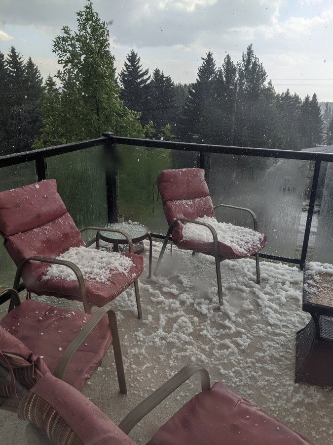
Calgary yesterday with yet another summer kicker hail storm..
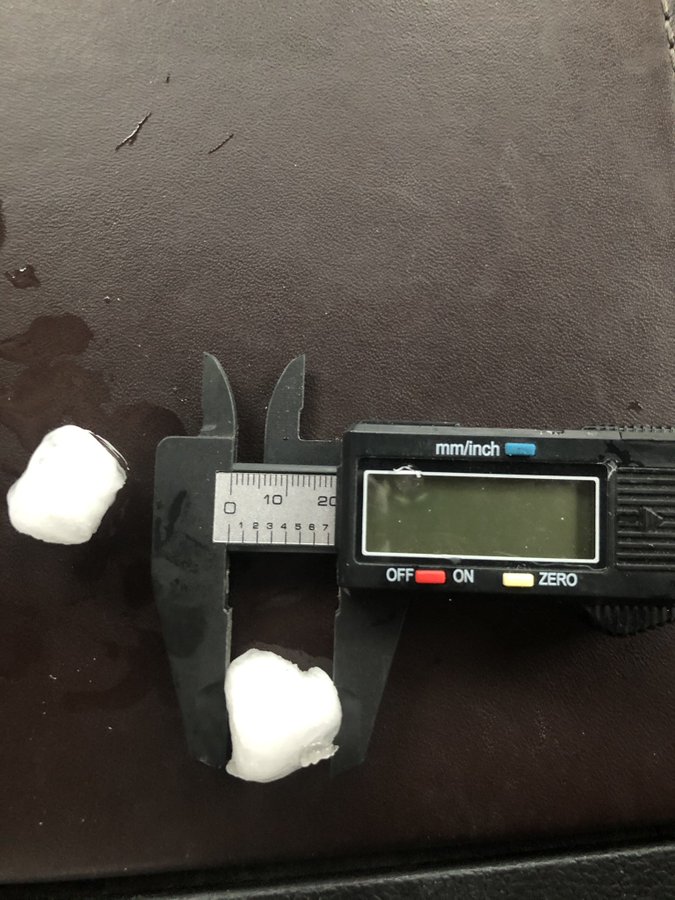
 ). I get anxiety (potential car and home damage) with the hail storms we get up here, and they’re nothing compared to the frequency and size of hail stones down there. It seems likes it’s a matter of when and how much hail damage you will have with your property down there
And that's why insurance rates are getting insane down there, and will continue to get worse and worse.Being in “hail alley” is a good reason to not want to live there, for me at least (also Flames fans
Lived in Calgary my whole life.Being in “hail alley” is a good reason to not want to live there, for me at least (also Flames fans
Lived in Calgary my whole life.
Have yet to receive any hail damage to any houses ive lived in, or any of my vehicles.